The settlement of Painswick has evolved into what it is today. I am inclined to the suggestion that the village developed during the Saxon period near the junction of two roads - an old road coming from what is now the Stroud area up past Wick Street and down Stepping Stone Lane (or thereabouts) into Painswick, and another old road that came from Bisley across the valley, along what is now Bisley Street and thence on to Gloucester. A rather different road system from what we now have.
Before that time, the area is likely to have had a flourishing population, though relatively sparse by modern standards. By the later Bronze Age, the local area had probably been largely cleared of forest for agriculture.
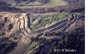
An Iron Age hill fort (500-100 BC) lies at the top of the Painswick Beacon, a mile and a half north of Painswick. The ramparts of the fort, known as Kimsbury, can still be seen. The location of the fort on a local high point on the Cotswold edge would have given this site its strategic importance. Today the site is worth a visit not just for the ramparts but also for the spectacular views up and down the Severn plain. But please remember that it is an ancient monument and also forms part of a golf course (created in 1891); there is a car park a short walk from the summit, or you can follow the Cotswold Way from the village.
Some ruins of a Roman villa (called Ifold and now covered over) have been found about half a mile northwest of the current village centre. This may have been the secluded residence of some important official, and would have had superb views down the valley.
Over many centuries local life was dominated by the manor. The earliest recorded lord of the manor was Ernisi in 1050. The village is recorded in the Domesday Book under the lordship of Roger de Laci, who was banished in 1096 for supporting a rebellion against the King. At this time, the village was known as Wyke (spelt in various ways). Pain FitzJohn, lord of the manor (1121-1137), is thought to have given his name to the village. The village gradually became known as Pain's Wyke, presumably to distinguish it from other villages of a similar name, and the current spelling evolved later. In 1253, Painswick was granted a charter to hold a weekly market.
At the time of Pain FitzJohn, the manor house is thought to have been located on the site currently occupied by Court House and Castle Hale. It was described as a castellum - a fortified mansion. The building ceased being used as the manor house in about 1445 and was demolished. The name, Castle Hale - the hall of the castellum - gives us an echo back to those times. Subsequently, The Lodge, about a mile northeast of the village and then set in a hunting park, became the manor house until 1831. Much of that house still exists and is now part of Painswick Court.
Feudal life in the manor for the ordinary man was harsh by our standards. The law was administered through the manor - in what were called Courts Leet, Courts Baron and Customary courts. Courts Leet generally tried minor criminal cases though in the case of Painswick also handled more serious ones. Punishments could be physical (e.g. the gallows, whipping post and stocks) or financial through fines. The last stocks, an iron version dating back to about 1840, can still be seen just outside the southern entrance of the churchyard. Courts Baron and Customary Courts handled property disputes between the lord of the manor and his tenants.
During the Civil War, King Charles I and his army passed through the parish on 9-10 August 1643 before laying siege to Gloucester, and on 5-6 September on their return. On 10 August, he issued a proclamation from his Court at Payneswicke ordering his soldiers not to molest, rob or spoil any people bringing victuals of any kind to his camp before Gloucester on pain of death. There were other skirmishes in the area during the Civil War, and one at the parish church.
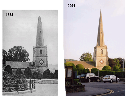
The parish church of Painswick, St Mary's, has grown over the centuries. The earliest parts, St Peter's Chapel, the north aisle and inner chancel, are thought to have been built between 1377 and 1401, possibly adjoining or replacing a Saxon or Norman church. The present nave and tower were started in about 1480, the spire added in about 1632, and the south aisle was built about 1741. A number of changes were made in the last quarter of the nineteenth century - including changes to make the building appear of a more uniform style. The church suffered a reverse on 10 June 1883, when at 5.08 p.m. it was struck by lightning. The top part of the spire fell down, some stone passing through the roof of the nave. However, it was rebuilt within six months, each stone being faithfully replaced in its previous position where possible. The belfry was overhauled in 1900, with the wooden timbers supporting the bells being replaced with an iron framework. Some of the timbers from the belfry were used in the construction of the lych-gate at the western end of the churchyard.
The churchyard, which is criss-crossed with paths, is graced with fine clipped yew trees and elegant tombstones. The tombstones come in many shapes and sizes. Local stonemasons elaborately decorated many of them, though some of the detail has been lost with the passage of time on the soft limestone. Most of the tombstones in the churchyard date from before 1860, when the churchyard was closed for burials. Subsequent interments took place in the cemetery on the slopes leading up to Painswick Beacon.
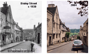
There are a number of fine old buildings, which have been or still are places of worship in Painswick. Christ Church in Gloucester Street was built in 1805 as a Congregational Church. Two chapels are now used as estate agents' offices - one in New Street was built in 1808 by the Wesleyan Methodists and the other in Bisley Street was built in 1854 by the Primitive Methodists. The Friends Meeting Room in Vicarage Street dates back to 1705. The Catholic Church in Friday Street was converted in 1934.
Painswick House, about half a mile north of the village, was built in 1735 by Charles Hyett. It was originally called Buenos Aires, because of the fine air in Painswick. The Rococo Garden was constructed about ten years later, and captured in a painting by Thomas Robbins. The original gardens fell into disuse, but the painting enabled their accurate reconstruction from the late 1980s.
Cloth weaving has been a fundamental part of the history of Painswick. The origins of the industry in Painswick are uncertain. However, it probably supported the substantial increase in population of the parish - from 118 families in 1495 to 186 families in 1700 and to 4099 persons in 1831. Initially, the industry would have been small-scale cottage based. Later, waterpower, from the relatively fast flowing Painswick Stream (and its tributaries), revolutionised the production of cloth. Some nineteen mills have been identified along these streams, though not all were involved in cloth manufacture at all times. For example, Cap Mill is known to have been producing cloth in 1729. The gradual introduction of steam power to the cloth industry - and the inability of Painswick's mills to take advantage of it - led to the industry's long-term decline in Painswick from after about 1830.
Many of the fine old buildings in Painswick can be traced back to the heyday of the cloth making industry. Built from limestone cut from local quarries, their construction was made possible by the wealth generated by the cloth making industry. The subsequent decline has also impacted on Painswick - in that many of these fine buildings were not replaced with newer ones!
The first known free school in Painswick was founded in 1725 for twenty poor boys of the parish to read, write and cast accounts. There may have been another (fee paying) school in 1704. By 1830 two girls schools had opened. The first purpose built premises were built in 1847, and opened as The National Schools (much of the building is now occupied by the library). It remained in use until the 1970s, when the Croft School was built.
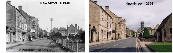
Two new roads were built in about 1820. The first connected Stroud to Pitchcombe and on to Gloucester, and the second connected Pitchcombe to Painswick at one end of New Street and from the other end of New Street extended on towards Cheltenham. New Street itself was built some two hundred years earlier. These roads (now known as the A46 and A4173) were driven across what were previously fields and transformed the local road network and access to Painswick. They were toll roads - Melrose Cottage on the Cheltenham Road is an old toll house. Prior to 1820, the main road from Stroud to Painswick passed on the other side of the valley (through Wick Street) and then down Stepping Stone Lane.
Many Painswick inhabitants were caught up in the first and second World Wars. Those who lost their lives are named on the memorial on the north side of the churchyard. Painswick itself suffered once, when on 14 June 1941 bombs fell in Friday Street demolishing some old buildings and damaging the Catholic Church. Their subsequent replacements are noticeable by their modernity amongst buildings that are several hundred years old.
Many of the utilities on which our lifestyles depend are historically relatively recent. Mains water and drainage systems were introduced in 1906, and the public bath house opened in 1924. The first telephones were installed in 1904. Electricity was brought to the village in the 1930s.
The last hundred years has seen other substantial changes. Although, the population in the parish has gradually increased from about 2,500 to just over 3000, the village has expanded dramatically in geographical size. There are now twice as many roads as then. For example, Cotswold Mead, Kingsmead, Blakewell Mead, Pullens Road and Canton Acre were open fields in 1920; Churchill Way and the roads off it were open fields in 1950s; Randalls Field was a field in 1970s. The improvement in transport (including the introduction of the motor car) and changing shopping and social habits has led to a dramatic decline in the number of local shops and inns.
Peter M Rowe, 2 June 2004, with later amendments
Main References:
1. A Cotteswold Village being the History of Painswick, W St C Baddeley, 1907.
2. Glimpses of the History of Painswick, F A Hyett, 1928.
3. The Painswick Chronicle, Painswick Local History Society, 1996-2002