INTRODUCTION
In this article I attempt to review the development of the roads in and around Painswick, from the earliest trackways to the 19th century turnpikes. I have looked at the early maps, the first of which to be of much use in searching out local roads is Taylor's map of Gloucestershire (1777). I have read some of the findings or theories of historians and archaeologists. For example, there was a book with map published in Cheltenham in 1881 called the Archaeological Handbook to the County of Gloucestershire by G. B. Witts; there were the learned amateurs like Baddeley at the turn of the century, Colleen Haine in very recent times, and the very thorough Christopher Cox in the 1960s who researched the building of the turnpike roads around Stroud.
I have walked round the neighbourhood tracing out the routes of some of the old roads and tracks on the ground, looking for depressions in the fields, trying to account for a sudden swerve or right angle, tracking ancient hedgerows, guessing the most likely course on a map and then trying to find some supportive evidence on the site. The relative depths of ancient hollow-ways give some indication of the age of a road. One might also be lucky enough to detect an ancient roadway by the casting of long evening shadows in pastureland, or discolouration in hot summer weather. The facts are hard to come by, and I admit that I have sometimes resorted to supposition in putting together this account.
EARLY TRACKWAYS
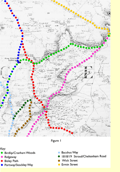
I start by considering the series of Iron Age settlements strung along the escarpment to east and west of our own Kimsbury Camp. Commencing at Leckhampton, through to Crickley Hill Camp, Birdlip, Brotheridge in Buckholt Wood, Kimsbury, Haresfield Camp - it is unthinkable that there would not have been communication between these settlements, a track linking them. This must be the origin of our present road from Birdlip through Cranham Woods, across what we now know as the Beacon, on to Seven Leaze Lane, through Edge to Haresfield Camp in Standish Wood (Figure 1 - light green dots). I believe this to be the oldest road passing through the parish, following a prehistoric track between the Iron Age fortresses.
Another ancient road is the ridgeway that runs from Birdlip to Bulls Cross and on along the very top of Frith Wood, over Wickridge Hill, down to Folly Lane and eventually to the Frome crossing at Dudbridge (Figure 1 - mauve dots). It is still possible to walk all but half a mile of this route. From Domesday times or even earlier it was part of one of the old Salt Ways (there were several). Salt of a high degree of purity was brought from Droitwich to the South Cotswolds (in this case as far as Sodbury) via Winchcombe, Cheltenham and Leckhampton.
Saltridge Hill, just north of Sheepscombe, provides strong evidence in support of this, but its position also suggests that the old Saltway, after following a more or less straight line in a south-westerly direction for a mile after leaving Birdlip, then left the path taken by today's road and headed for Overtown Farm, passing along the east side of Saltridge Hill to the centre of Sheepscombe, and so to Longridge and Bulls Cross.
This old road, from Bulls Cross to the south, was also the original route from Painswick to Dudbridge and beyond, long before Stroud came into being, until superseded by Stepping Stone Lane and Wick Street (Figure 1 - brown dots), following the development of New Street in the early 15th century. This was only one of several major roads that met at Dudbridge in order to cross the Frome.
Dudbridge is first documented in the late 12th century. Without a doubt it has been a crossing point since prehistoric times. The old bridge has recently been carefully dismantled and re-assembled by courtesy of Messrs. Sainsburys.
THE BISLEY PATH
Neither of these ancient roads, however, actually passed through the village. For centuries, the main highway through Painswick was what we now call Bisley Street, formerly known as High Street. This was the ancient road that ran between Gloucester, Painswick, Bisley and Cirencester (Figure 1 - red dots).
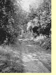
Leaving Gloucester Eastgate, it passed through Matson, Upton, Kimsbury Camp, Painswick (Gloucester Street, Bisley Street and Tibbiwell), Bulls Cross (see photo left), Steanbridge (first documented in 1248), up to its highest point at Stancombe crossroads, and so on over the Frome at the Gulph, passing through what is now Cirencester Park, and entering Cirencester by Cicely Hill. At the Cirencester end it was known as The Bisley Path, and is still so marked on the 1991 2½" Ordnance Survey map, in the Cirencester Park section.
Until the end of the 18th century, this was also the preferred route for travellers from Stroud to Cirencester, but with the construction in 1814 of the turnpike road from Stroud to Cirencester through Minchinhampton and over Aston Down, the Bisley Path fell into disuse and was de-piked. For some time after that, however, it was still being advised as a wet-weather route! Much of the eastern end is now no more than tracks and footpaths, and some of it even untraceable.
Christopher Cox 1 goes to some length to support the view that this road was in use in Roman times. He sums up his arguments thus:
".....taking together the various Roman sites on or near the line of the route, the fact that it was a much-used highway for several centuries, and the evidence of topography that it is the only really feasible way across the headwaters of the system of the Frome from east to west between Ermin Street and the Minchinhampton plateau, it seems not unreasonable to think that the way called here the Bisley Path was in essence, and at certain points, the actual route used in Roman times between Glevum and Corinium for the villas and settlements between those two important urban centres."
The route of this road in the vicinity of Painswick has not changed for hundreds of years, with one intriguing exception. At the lower end of Bisley Street (formerly High Street), the road now turns sharply to the right, passing along the south side of the old market square, before turning left down Tibbiwell Lane. Baddeley 2 must be right when he states that the road originally passed through the site of modern houses on the south side of Vicarage Street, and continued on in a straight line down to Tabitha's Well. He suggests that the change came in 1820, but why the deviation came about is something of a mystery.
THE PORTWAY
According to the 19th century archaeologist Witts 3, there was another ancient route passing close to Painswick, known as The Portway. This connected Glevum (Gloucester) to Aquae Sulis (Bath). It left the city by the East Gate, ran from there to Matson and Upton St Leonards where it ascended the scarp to a point "below Kimsbury Camp" (in his words). Passing along the brow of the hill above Brookthorpe, it went over Horsepools, along the top of Standish Park, below Randwick Camp, down to Pagan Hill, and so on to Woodchester and the Nailsworth valley. The considerable number of Roman villas, stations and camps clustered along this road suggests that this route was a main road in Roman and probably pre-Roman times (Figure 1 - dark blue dots).
A word of warning is needed at this point to avoid confusion. Local readers will tend to think of the Portway as the ancient hollow-way between Upton St. Leonards and Prinknash Park, but Witts described this road as a branch off the 'real' Portway.
However, road-building did not begin with the Romans! They built their long straight roads such as Ermin Street (Figure 1 - yellow dots), Akeman Street, Fosse Way, necessary for the swift deployment of armies and the maintenance of rapid communications. They also made much use of the old British trackways, and developed them for access to the numerous villas and farms that sprang up during their occupation, especially in the Cotswolds. Villas such as Ifold and Brownshill were reached by adapted British tracks. They were essentially roads used by local communities over shorter distances. They took into account difficult topographical features such as rivers and steep gradients and went round them instead of confronting them. Not all Roman roads were straight!
There are one or two indications of routes taken by local roads in Roman times. In a nondescript patch of grassland, below Cud Hill and behind Hazel Grove, there lies buried beneath the surface a stretch of paved track which is said to be probably Romano-British in origin 4. I have seen a photograph of this paving taken at some time recently when it had been uncovered, but all you can see if you walk there at present is the large kerbstones running on both sides for about 100 yards. This suggests that before the present road down to Upton was developed, there was an earlier (paved) track well to the west of Hazel Grove which climbed up to the point in Seven Leaze
Lane where King Charles's Stone stands today.
A further pointer to the Roman use of the roads we still travel over today is found in the derivation of certain place-names, e.g. Strat-ford, where today's Wick Street crosses the Wick stream. Baddeley 5 believed that the Strat- element was derived from the Latin strata, or street. If so, the meaning of Stratford would be "the ford carrying the Street", i.e. Wick Street.
Wick Street appears to be a very old road, perhaps Roman, which ran from the present Stratford Park to Bulls Cross. It became more important to Painswick when New Street was developed in the early 15th century, and then, as the volume of traffic increased, it replaced the ridgeway from Bulls Cross as the main route from the village to Stroud. McWhirr 6, by the way, tells us that the occurrence of the word "straet" in Saxon charters, indicates a properly laid road surface rather than a dirt track, and this is a clue to the status of Wick Street in early times.
MEDIAEVAL ROADS
In mediaeval times, the busy routes already described continued to be heavily used. We find fascinating evidence on the ground of the way local roads have come and gone. Greenwood's map of 1824 shows two tracks climbing up the Cotswold escarpment, one from Brookthorpe, the other from Upton.
Both of these tracks, now mere footpaths through fields, were important access roads from Gloucester to the Cotswolds in their day. They both climb directly up the steep scarp, making no attempt to ascend by means of zig-zags. This is so typical of the roads in use before the days of wheeled traffic. Pack-horses, pedlars and other foot travellers were mainly concerned in getting to their destination by the shortest possible route, so long as it was relatively dry. They were not put off by steep hills.
The way from Brookthorpe, known as Bacchus Way (Figure 1 - light blue dots),was for hundreds of years part of the direct route from Gloucester to Stroud. It was defended by a series of earthworks at the top, the Huddinknoll entrenchments, according toWitts 7, and there is on record an account of a sharp encounter here during the Civil War 8, but the signs are that the earthworks are of far older construction.
This road, having fallen into a bad state of repair, was turnpiked in 1726, and a further Act of 1746 to clarify the earlier Act said that the road was too long and ruinous to repair from parish rates, "many heavy carriages frequently passing thereon". When it came to the point, however, there was not enough money to carry out improvements from toll income and the road fell out of use, to be replaced by the new road from Brookthorpe to Horsepools in 1817. It was still a charge on the parishes in the 1830s and 1840s.
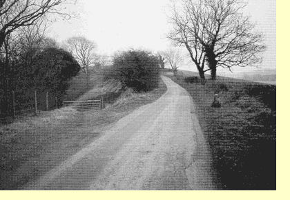
There are indications that the old road up from Upton, now no more than a grassy track in its upper stretch, was well used at one time. For one thing, it was equipped with mounting blocks at top and bottom, the lower one still stands outside the Kings Head, and the other, if my guess is right, is the stone that stands beside Seven Leaze Lane and is known to us as King Charles's Stone (see photo left). This old route leaves the modern road just above the Hatton Court Hotel, passes behind Hazel Grove (over the piece of Roman pavement I mentioned earlier), and then heads straight up Cud Hill. The old name for this track was Stockley Way.
Among the antiquarians, only Baddeley appears to make any mention of the earlier routing of this road. My own view is that it was in use certainly until the mid-17th century, and that it was probably up this track that Charles I retreated from the siege of Gloucester in 1643. It would have been here, then, that his two young sons came to him and put the famous question "When shall we go home?" 9 At some point that old track was replaced by the present road. Perhaps this happened when wheeled vehicles (particularly those carrying stone from the quarries on the Beacon) required an easier gradient. That may have been after the Charles I incident, but before the appearance of Taylor's map in 1777.
KINGS WITH THEIR ARMIES
Charles I was not the first king to bring an army through these parts on the way to battle. In 1471, during the Wars of the Roses, Edward IV came this way. He was chasing Queen Margaret's army, trying to prevent her reaching Wales. In a celebrated march, he brought his army along the Cotswold Ridgeway from Sodbury. Margaret's army had a much more difficult traverse through the low-lying lands of the Vale. By choosing the higher road, Edward could watch her progress, betrayed probably by the great cloud of dust which such a large number of men and horses would create. Both armies marched 30 miles in one day (Churchill in his History of the English Speaking Peoples (Vol I) says it was 40 miles!). Edward came through Woodchester, crossed the Frome at Dudbridge, moved on to Cainscross, climbed up the hill at Paganhill and Whiteshill, to the top of Standish Park, then along to Horsepools and Kimsbury Camp and so down to Upton 10. Both armies arrived exhausted at Tewkesbury, where the King brought Margaret to battle and defeated her at the Battle of Tewkesbury. I myself think that Edward's army probably passed down this now disused Stockley Way.
THE SPOONBED VALLEY
The rich fertile lands of the Spoonbed Valley belonged to the monks of Llanthony Priory Secunda in Gloucester. It must have been down the two ancient roads to Brookthorpe and Upton already described that much of the farm produce passed on its way to the markets and docks.
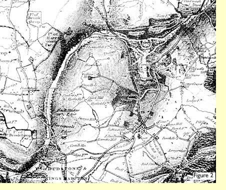
A network of minor roads criss-crossed the valley between the farms and villages. This is well brought out in Bryant's map of 1824 (Figure 2, left). The valley is bisected by the ancient hollow-way that passes Holcombe House before joining Seven Leaze Lane. Baddeley 11 suggests that this would have been the natural route for villagers to get to Gloucester, and they would have left the village along Blakewell Lane, now known as Edge Lane.
One road that traversed the Spoonbed valley is now no more than a footpath running between high hedges. You can still walk the length of it from a point just north of Highfold Farm to Edge Farm. Aerial photographs reveal that this one-time road passed through ancient field systems and inhabited settlements in the Washbrook valley which had probably disappeared by the time of the Conquest.
THE COMING OF THE TURNPIKE ROADS
By the end of the 17th century, the state of the roads in Britain was a national disgrace. No serious road-building had been carried out since Roman times. During the 16th and 17th centuries the number of wheeled vehicles increased rapidly. Not only did they cause damage to road surfaces, but they also created a demand for better roads to match the potential for swifter travel.
The problem, as always, was money! The will of Lady Margaret Choke, widow of Sir Richard Choke, Lord Justice of the Comyn Pleas, 1483 (12 years after the Battle of Tewkesbury), illustrates the haphazard way in which funds were raised for the maintenance of roads in the middle ages:
Item: XX£ to be spent there where most need is for to mend badde weys in Gloucestershire for the soul of my husband, William Gifford [her first husband], and me.12
During the 16th century a major step forward in local administration had been taken by requiring a parish to appoint two highway surveyors to be responsible for the upkeep of its roads, and making each parish bear the cost of such maintenance without outside assistance. This was a crude method and grossly unfair. I have already mentioned Bacchus Way, the road up from Brookthorpe, and the inability of the parishes to keep it in good condition.
The remedy to this national scandal was to authorise the setting up of Turnpike Trusts, with power to raise an income from tolls to be applied to maintenance. The changes brought about by the construction of a nation-wide turnpike system have been described 13 as one of the most striking developments in the history of transport.
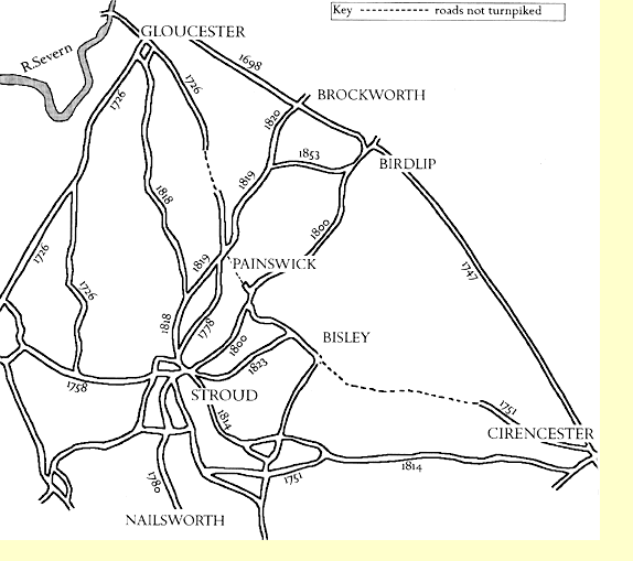
The earliest Turnpike Act in Gloucestershire (1698) applied to the two roads from Gloucester to Crickley Hill and Birdlip. Defoe 14 describes this latter road as "....formerly a terrible place for poor carriers and travellers out of Wales, etc., but now repaired very well".
A number of roads radiating from Gloucester were turnpiked by an Act of 1726. Among them were the two roads previously mentioned, climbing the scarp from Brookthorpe and Upton. In 1751, it was the turn of the eastern end of the old road from Cirencester through Bisley (the Bisley Path), followed in 1778 by Wick Street from Stroud to Painswick.
Wherever a road was turnpiked there had to be toll-houses and probably milestones. Quite a number of these milestones remain, albeit in a damaged condition. There is a record in 1733 of a toll-gate at the entrance to Butt Green, later moved a little further up the road to Pound House. This Barton Street Turnpike was said to have made a clear profit of £422 in 1817, which gives some idea of the traffic between Painswick and Gloucester. In 1843, £100 shares in the Painswick-Gloucester road were available, having produced 5% interest the previous year.
There were constant complaints about the failure of these older turnpikes. For example, Samuel Rudder who travelled the county in the late 1770s seeking material for his County history, wrote about the major Bristol-Gloucester turnpike:
".....surely there cannot be a more infamous turnpike road... for incredible as it may seem, the writer of this account, in the winter of 1776, saw a chaise mired in it, about half a mile from the Swan Inn (in Wheatenhurst), and was there told, that a horse had like to have been smothered in the same place two days before, but was luckily saved by some persons coming accidentally to the poor animal's assistance." 15
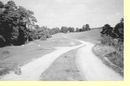
No such problems appear to have beset King George III when, twelve years later, during his famous visit to Cheltenham in 1788, he took time off to visit Onesimus Paul at Woodchester. He came from Leckhampton and Birdlip, Buckholt, Prinknash. and then by the old road that ran through Pope's Wood, across the Beacon (see photo left), as it is called now, and so into Painswick on the Gloucester Road, and out again by the turnpike road, Stepping Stone Lane and Wick Street.
This was the route taken also by the regular Cheltenham-Bath stage-coaches. At this time there was also a regular coach travelling from Gloucester to Bath through Painswick. It took just one day, and the fare cost 11 shillings.
THE NEEDS OF THE MILLS
Roads in the Stroudwater district at the beginning of the 19th century fitted into one of three main categories 16. There were the long-distance roads, the so-called 'Great' roads crossing the plateau, linking the major towns and cities such as Gloucester, Oxford, Bath, etc. These roads are still in general use today.
Then there were the local roads running more or less horizontally along the hillsides, connecting settlements, and usually following the contours just above the spring line, e.g. Wick Street.
But there was a third category - the vertical roads that led up and down the hillsides from the mills to the local roads, essential to getting goods and products in and out of the mills. Some of these are still in use, like Pincot Lane. Others have gone out of use but have left traces of their existence - like Ticklestone Lane and the path above Lovedays Mill.
At the turn of the century we come to the peak of the industrial activity around the village. It was the beginning of the period in which the local manufacturing processes were shifting from cottages to mills. The masters needed improved communications to and from the mills, and easier roads to the plateau. They had greatly benefited by the French wars, and expected their prosperity to continue.
THE NEW ROADS
So there came the second wave of turnpike roads in the district - new roads - the motorways of the time. Wide roads, easy gradients, gentle curves, metalled surfaces employing the new invention by Macadam - a generation grew up using routes unheard of by their fathers.
In 1800 the road from Stroud to Birdlip was built up the Slad valley via Bulls Cross. In 1818, Stroud was connected to Gloucester by a totally new route, the road over Horsepools Hill. The following year the stretch from Pitchcombe through Painswick to Prinknash Park was built, and in 1820 it was extended to Cheltenham. These were all toll roads. New toll houses came into being on this Cheltenham road, and the house in Cheltenham Road we know today as Melrose was one of them.
A whole new network had come into existence in the space of 20 years. The final throw came in 1853 when the old road through Buckholt and Cranham Woods was turnpiked. These were only a fraction of the new roads throughout the Stroud valleys as a whole. The revolution meant that a number of old roads went out of business, along with the inns and other industries that lined them.
The road from Bulls Cross to Bisley and Cirencester, and the ancient track up from Brookthorpe to the scarp became no longer viable. Wick Street and Tibbiwell Lane lost much of their importance. The old road across the Beacon was completely superseded by the road (the modern A46) built under the supervision of Charles Baker, of Castle Hale, in 1819 (Figure 1 - dark green dots).
By 1825, however, the mills were in decline and there was no need or scope for new roads. From now on there was to be little change in the road system in and around Painswick. There was a suggestion of a by-pass in the 1930s, of course, and if there is ever to be extensive development in the Painswick valley, who knows what the future might hold ...!
References