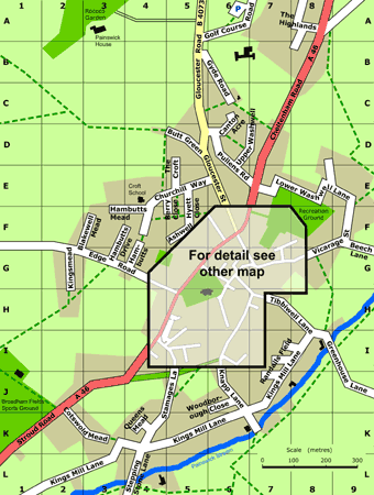
Beech Lane F9-G9
Berry Close E4-F5
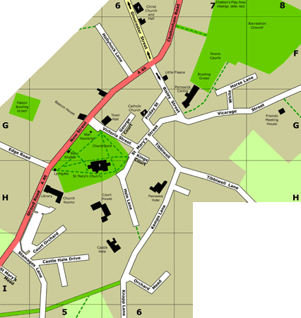
Bisley Street F6-G7
Blakewell Mead F2-F3
Butt Green D5
Canton Acre D6-C6
Castle Close / Castle Hale Drive I5
Cheltenham Road F6-A8
Churchill Way F4-E5
Cotswold Mead K2-K3
Court Orchard I5
Edge Road G1-H5
Friday Street (formerly Bell Street) G6
George Court G6
Gloucester Road A5-D5
Gloucester Street D5-F6
Greenhouse Lane I8-I9
Gyde Road B5-C6
Hale Lane H6
Hambutts G4-F4
Hambutts Drive G3-F4
Hambutts Mead F3-F4
The Highlands A8
Hollyhock Lane F6
Kemps Lane (formerly South Street) H6-I6
Kings Court G6
Kingsmead G2
Kingsmill Lane L1-I8
Knapp Lane (formerly South Street) I6-J6
Lower Washwell Lane E7-E9
New Drive J4-I6
New Street G5-F6
Orchard Mead I6
Pullens Road D6-E6
Queensmead K4
Randalls Field J7-I8
St Mary's Street H6-G6
St Mary's Mead I4
Stamages Lane I4-K4
Stepping Stone Lane L4
Stroud Road L1-H5
The Croft D5-E5
Tibbiwell (Street)/ Tibbiwell Lane G6-H8
Upper Washwell D6-D7
Vicarage Street G7-F9
Victoria Street G5-G6
White Horse Lane G7-F8
Woodborough Close J6